Whiteface Mountain is a 4,867 foot peak located in The Adirondack Mountains of New York State. It is ranked fifth in height, of the the “46ers”, and first in development. The memorial highway is a paved road that can be accessed by car during the on-season for $16 per person. Many hikers pair Whiteface with Esther Mountain
Quick Navigation:
Trail Options | Trail Map | Directions | Winter | Weather | Photos
Height – 4,867 feet (1,483.5 m)
Elevation Gain – 3,578 feet (1,090.6 m)
Distance – 9.3 miles roundtrip (14.97 km)
Duration (book time) – 6 to 7 hours
Difficulty – Strenuous
Trails
Wilmington Trail (Primary Trailhead): Begin at the Atmosphere Science Research Center trailhead parking area. Start your hike on the Wilmington Trail, until you reach the summit of Marble Mountain after a steep climb. From the top Marble Mountain, there will be an intersection, make a right turn here. The terrain will flatten out for about 1.5 miles until you come across a large cairn at an intersection. This the herd-path to Esther Mountain, continue straight as the trail climbs steeply up an open ridge with incredible views. You will reach the summit of Whiteface Mountain shortly after. To descend, simply retrace your steps back to the trailhead parking lot where you began.
Distance – 9.3 miles round trip
Duration – 6 to 7 hours
(Secondary Trailhead) – Begin your hike from the Reservoir Road trailhead parking lot, a 4.7 mile one-way hike to reach the summit of Whiteface Mountain. This route is slightly easier grade than the primary trail, with more elevation to gain. From the trailhead you will hike through an open forest for about 1.2 miles where the trail begins to steepen a bit until reaching the summit of Marble Mountain. From the top Marble Mountain, there will be an intersection, make a right turn here. The terrain will flatten out for about 1.5 miles until you come across a large cairn at an intersection. This the herd-path to Esther Mountain, continue straight as the trail climbs steeply up an open ridge with incredible views. You will reach the summit of Whiteface Mountain shortly after. To descend, simply retrace your steps back to the trailhead parking lot where you began.
Distance – 9.4 miles round trip
Duration (book time) – 7 hours
Whiteface Landing Trail (Third Trailhead) – From the trailhead at Connery Pond, begin your hike after passing by the gate. It is 5.7 miles to reach the summit, one-way. The hike begins along an old gravel strewn woods road, and the footing is tough in spots due to rocky terrain. Continue until you reach Whiteface Landing. From Whiteface Landing, take a sharp right turn towards the Whiteface Brook Lean-to. The trail is flat most of the way to the lean-to, but begins to climb steeply shortly after. The final push before the summit is rocky, extremely steep, and rugged. Continue climbing until you reach the summit of Whiteface Mountain. To descend, retrace your steps the way you came until you reach the trailhead parking lot where you began.
Distance – 11.4 miles round trip
Duration (book time) – 7 hours
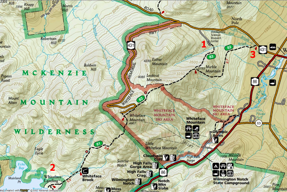
Trail Map
On the map below, in red, we have denoted the starting point for each of the trail options we mentioned above.
Directions
Primary trailhead – From the intersection of Route 73 and Route 86, follow Route 86 toward Wilmington. Drive into Wilmington and take a left onto Route 431 (Whiteface Mountain Road) Follow the road for 2.4 miles to the Atmospheric Science Research Center Road which will be on your left. Follow the road around the one-way roundabout, past a dirt road where the trail begins. The trail is not labeled with a sign.
Secondary trailhead – From the intersection of Route 73 and Route 86, follow along Route 86 into Wilmington. Make a left turn onto Route 431 (Whiteface Mountain Road) and continue driving for 0.6 miles to Reservoir Road which will be on the left hand side. Drive to the end of the road and park here. Directions here.
Third trailhead – From the intersection of Route 73 and Route 86, follow along Route 86 into Wilmington. Drive for roughly 3 miles to reach the Whiteface Trailhead on the left. Park here and begin hiking. Directions here.
Hiking In Winter
Whiteface Mountain a popular ski resort with the greatest vertical east of the Rockies. It is a popular mountain to visit in the winter, by foot, by ski, and by board. The most popular winter trailhead hikers can access is via the Wilmington Trail from the Atmosphere Science Research Center. This is a 7.2 mile hike round trip that takes roughly 7 to 8 hours to complete in winter conditions.
*NOTE* Be aware of heavy winds and frigid temperatures on the summit and along the upper ridgeline. It is advised that hikers are prepared with a full face mask, snowshoes, and foot traction to manage the icy sections.
Weather
Here is a detailed weather forecast for the next four days:
Wilmington, NY
Tonight
A chance of snow showers before 1am. Mostly cloudy, with a low around 13. Wind chill values as low as 0. West wind 13 to 21 mph. Chance of precipitation is 40%. New snow accumulation of less than half an inch possible.
Monday
A chance of snow showers after 1pm. Partly sunny, with a high near 20. Wind chill values as low as -1. West wind 9 to 14 mph.
Monday Night
A chance of snow showers. Mostly cloudy, with a low around 15. West wind around 13 mph.
Tuesday
A chance of snow showers. Mostly cloudy, with a high near 19. Wind chill values as low as 0. West wind 13 to 18 mph.
Tuesday Night
A chance of snow showers before 7pm. Mostly cloudy, with a low around 11. West wind 16 to 20 mph.
Wednesday
Snow showers likely after 1pm. Mostly cloudy, with a high near 23. Southwest wind 15 to 22 mph. Chance of precipitation is 60%. New snow accumulation of less than one inch possible.
Wednesday Night
Snow showers. Cloudy, with a low around 20. Southwest wind 23 to 36 mph. Chance of precipitation is 100%. New snow accumulation of less than one inch possible.
Additional Photos
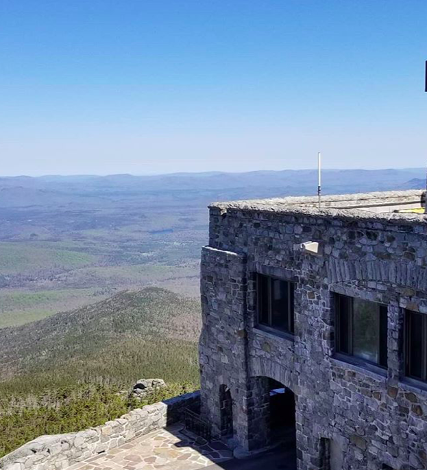
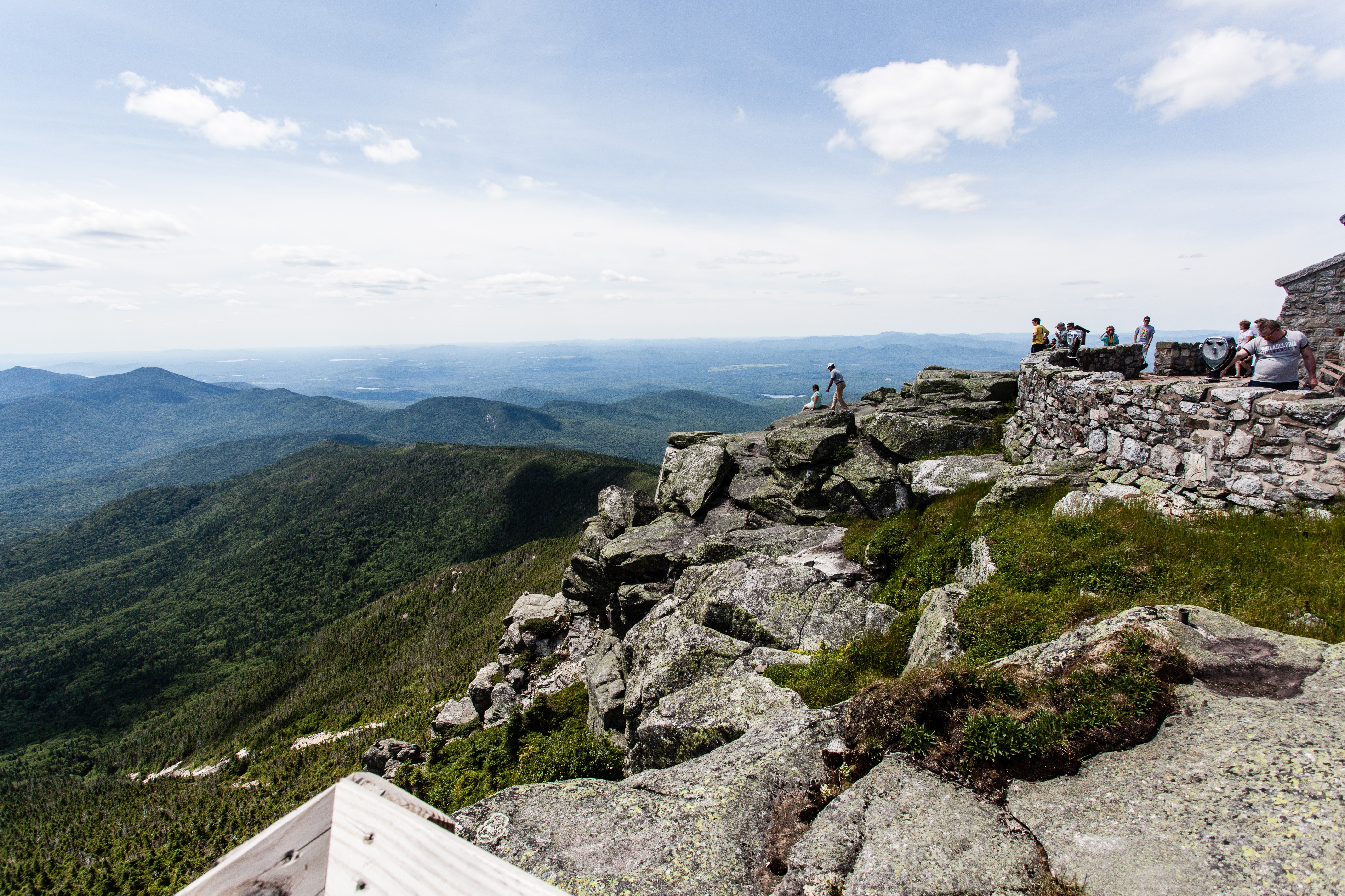
Photo credit: Geoffrey Williams: Flickr