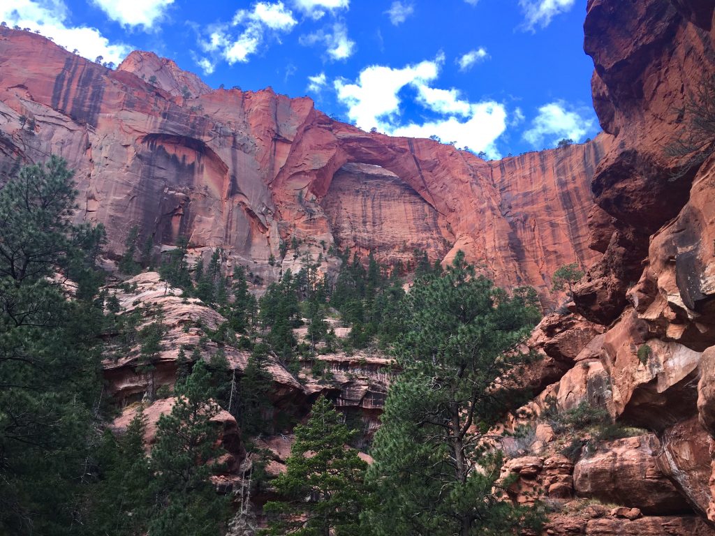
Kolob Arch is known as the 6th largest arch in the world at with a span of about 287 feet. It is located in the northwestern portion of Zion National Park and is hiked frequently as a day hike, or an overnight hike. There are 13 campsites that can hold between 4-12 people. There are two common ways to hike to the Arch, each of them are discussed below.
Distance: 14 miles
Difficulty: Intermediate
Duration: 5-9 hours

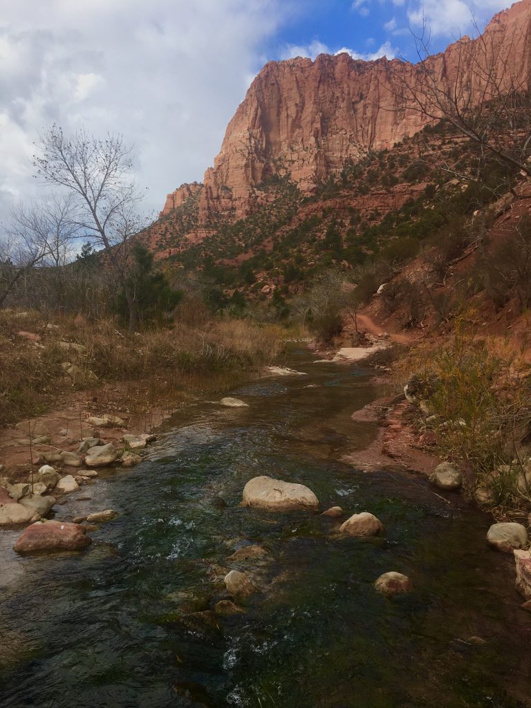
Picture from the La Verkin Creek trailhead parking area. (You can see La Verkin Creek Trail along the small ridge)
La Verkin Creek Trail
The La Verkin Creek Trail is a 14 mile round trip trail to Kolob Arch beginning at Lee Pass off of E Kolob Canyon road in the northwestern portion of Zion National Park. This trail features smooth walking with a well traveled trail that meets up with La Verkin creek. From the very beginning of the hike, you see incredible views of the surrounding mountains and red rock cliffs. Where the trail meets La Verkin creek, hikers will find a gorgeous waterfall and pool of water for a dip.
Hop Valley Trail
The Hop Valley Trail is a 14 mile round trip trail to Kolob Arch, located of of Kolob Terrace road. This trail starts at a high elevation around 1,000 feet above the viewpoint to Kolob Arch, making the trek back more difficult. Hikers will begin by hiking in open territory with gorgeous views of incredible rock formations in all directions. The path is very well used, and easy to follow. Both paths to the arch are great options and easy to follow.
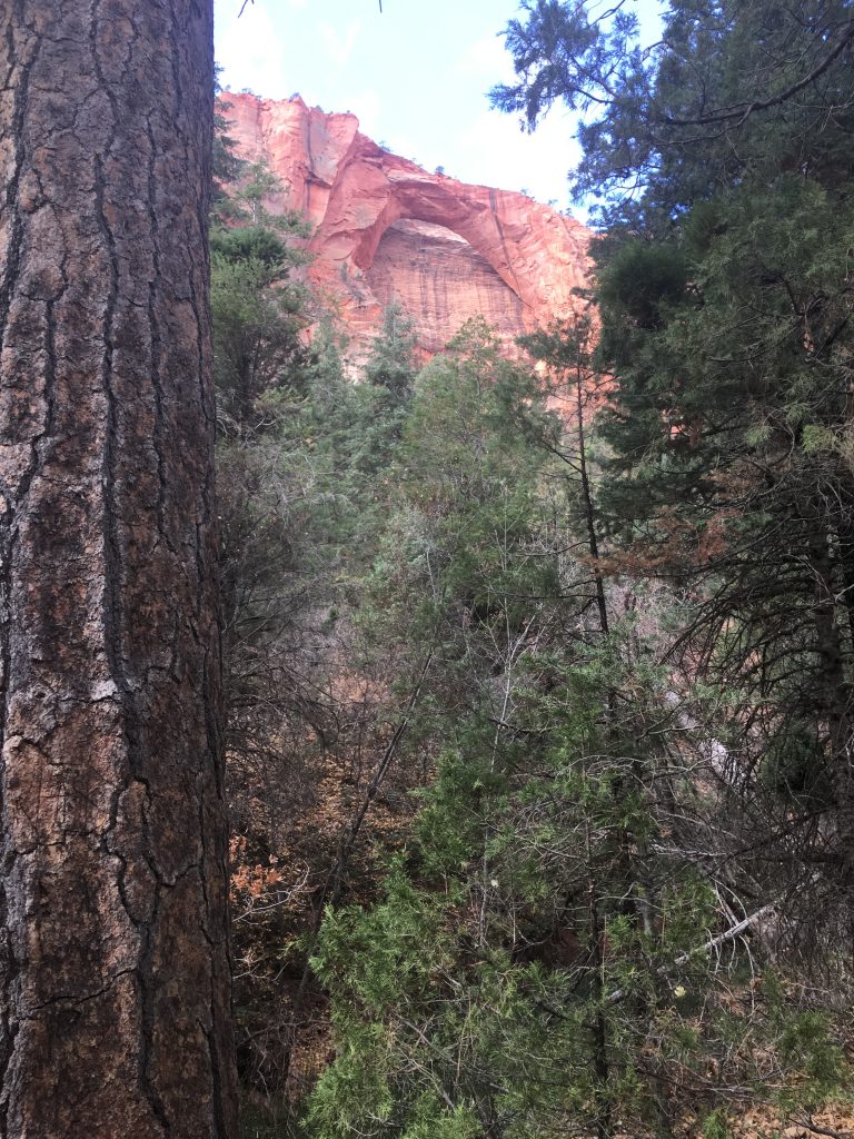
Kolob Arch Trail
Both Trails converge at the start of the Kolob Arch Trail, which is a very cool .5 miles out and back trail (1 mile total) to the viewpoint of Kolob Arch. At the end of the trail, you will see the arch through the tall trees surrounding the trail. At the end of the trail, there is a slightly warn path leading up to a rock formation that, with a quick climb, leaves perfectly clear views of the arch.
Camping
There are 12 campsites along the La Verkin Creek Trial indicated on the map. Some are as close as .5 miles to Kolob Arch, while others are much closer to the La Verkin Creek Trailhead.
All of the campsites have quite a bit of space for tents and are well used. Water isn’t near all campsites so pack accordingly. All water collected should be filtered.
Hikers must book campsites ahead of time. Booking campsites is done at the Zion Wilderness Deck, or at the Kolob Visitors Center. When booking, you will be able to pick from the remaining available campsites.
Camping Fees:
$15.00 – 1-2 people
$20.00 – 3-7 people
$25.00 – 8-12 people
Trail Map
Hop Valley Trail

La Verkin Creek Trail Map

Directions
To Lee Pass Trailhead (LaVerkin Creek Trail)
To Hop Valley Trailhead
Other Zion National Park Hikes
If you are a little nervous about hiking the Angel’s Landing trail, or maybe need a few extra hikes in Zion, you should absolutely check out the following:
You should also check out our guide to the best hikes in Zion.
Weather Forecast
Kanarraville, UT
This Afternoon
Mostly cloudy. High near 54, with temperatures falling to around 47 in the afternoon. West northwest wind around 3 mph.
Tonight
Mostly cloudy. Low around 30, with temperatures rising to around 33 overnight. East northeast wind 2 to 6 mph.
Monday
Sunny. High near 55, with temperatures falling to around 47 in the afternoon. East wind 2 to 6 mph.
Monday Night
Partly cloudy, with a low around 32. Northeast wind 2 to 7 mph.
Tuesday
Partly sunny, with a high near 58. East wind 1 to 6 mph.
Tuesday Night
Partly cloudy, with a low around 32.
Wednesday
Sunny, with a high near 57.
Additional Pictures
Max DesMarais is the founder of hikingandfishing.com. He has a passion for the outdoors and making outdoor education and adventure more accessible. Max is a published author for various outdoor adventure, travel, and marketing websites. He is an experienced hiker, backpacker, fly fisherman, backcountry skier, trail runner, and spends his free time in the outdoors. These adventures allow him to test gear, learn new skills, and experience new places so that he can educate others. Max grew up hiking all around New Hampshire and New England. He became obsessed with the New Hampshire mountains, and the NH 48, where he guided hikes and trail runs in the White Mountains. Since moving out west, Max has continued climbed all of the Colorado 14ers, is always testing gear, learning skills, gaining experience, and building his endurance for outdoor sports. You can read more about his experience here: hikingandfishing/about