Ensign Peak is a prominent hill on the northern edge of the Salt Lake Valley in Utah. It rises above the Utah State Capitol and offers a panoramic view of Salt Lake City and its surrounding areas, including the Great Salt Lake and the Wasatch Range. The peak is historically significant, especially to members of The Church of Jesus Christ of Latter-day Saints (LDS Church), often known as Mormons. Here’s everything you need to know about this hike.
Distance – 1.04 miles round trip (1.7 km)
Height – 5,360 feet (1634 m)
Elevation gain – 367 feet (112 meters)
Duration – 1-1.5 hours
Difficulty – Easy to Intermediate
Trailhead Locations – Ensign Peak Trailhead
Dogs: Allowed
Ensign Peak History
According to LDS Church history, just two days after arriving in the Salt Lake Valley on July 24, 1847, Brigham Young and several other early Mormon leaders climbed to the top of what they named Ensign Peak. From there, they surveyed the valley and laid plans for what would become Salt Lake City. The name “Ensign” comes from Isaiah 5:26 in the Old Testament, symbolizing a standard or banner raised to gather people, fitting the pioneers’ view of their new settlement as a spiritual gathering place.
Today, Ensign Peak is a popular hiking destination due to its historical significance and the relatively easy, short hike to the summit, which is about one mile round trip. At the peak, there is a monument commemorating the early settlers. The area around Ensign Peak has also been developed into a park, providing a space for reflection and enjoyment of the natural beauty surrounding Salt Lake City.
Tips For Ensign Peak
- If it has recently rained, this route can get very muddy. It may be a good idea to avoid after rainfall due to this.
- Avoid the hottest parts of the day, as this trail can be quite hot.
Trail Description
Hikers start at the trailhead on Ensign Vista Drive via a trail that has some gorgeous steps, monument like structures, and signs explaining the history of the area.
The trail is paved at the beginning, and offers a shorter distance viewpoint that is fully paved only a couple hundred feet into the hike. Hikers who want to go all the way to the top simple follow the dirt trail heading upwards. The trail is relatively steep, but can be accomplished in regular sneakers. Be weary of muddy conditions if within a few days of rainfall.
There are several spots where the trail splits into two sections and comes back together. Choose the path best for you. Eventually, hikers will make it up to a viewpoint that looks East, and is the saddle between the Ensign Peak viewpoint, and trails that head further up into the foothills. At this saddle, hikers head left, and can see the Ensign Peak viewpoint only a few hundred feet away.
Hikers simply retrace their steps back to the parking area.
Trail Map
Hiking Ensign Peak In Winter
This peak is low elevation and open year round. Because it is low elevation and mostly exposed to the sun, it can generally be hiked year round. Shortly following any storm, it can be icy, snowy, and muddy, but is one of the more common winter hikes in the area because of the ease of access.
Current Weather Conditions:
Here is the detailed weather forecast for the next few days. We highly recommend you check out local weather the morning of your hike.
Salt Lake City, UT
Today
Sunny. High near 43, with temperatures falling to around 37 in the afternoon. North northwest wind around 1 mph.
Tonight
Partly cloudy. Low around 30, with temperatures rising to around 32 overnight. Northeast wind around 1 mph.
Monday
Haze after noon. Mostly sunny. High near 45, with temperatures falling to around 39 in the afternoon. North northwest wind around 1 mph.
Monday Night
Haze. Partly cloudy, with a low around 32. East northeast wind around 2 mph.
Tuesday
Haze. Mostly sunny, with a high near 45. Northwest wind around 1 mph.
Tuesday Night
Haze. Partly cloudy, with a low around 31.
Wednesday
Haze. Sunny, with a high near 45.
Directions & Parking
Parking for this trailhead is simple as it is roadside parking in a neighborhood. You can park as close to the trailhead as you can. Avoid blocking any driveways, and follow parking signs.
Additional Pictures

Looking at Ensign Peak form a nearby peak
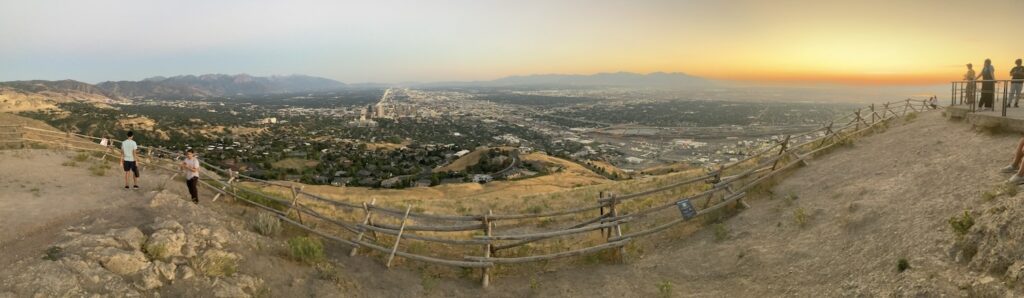
Ensign Peak panoramic views
Max DesMarais is the founder of hikingandfishing.com. He has a passion for the outdoors and making outdoor education and adventure more accessible. Max is a published author for various outdoor adventure, travel, and marketing websites. He is an experienced hiker, backpacker, fly fisherman, backcountry skier, trail runner, and spends his free time in the outdoors. These adventures allow him to test gear, learn new skills, and experience new places so that he can educate others. Max grew up hiking all around New Hampshire and New England. He became obsessed with the New Hampshire mountains, and the NH 48, where he guided hikes and trail runs in the White Mountains. Since moving out west, Max has continued climbed all of the Colorado 14ers, is always testing gear, learning skills, gaining experience, and building his endurance for outdoor sports. You can read more about his experience here: hikingandfishing/about
Cloudy Weather, But Great Views
Trail was in good shape with little to no mud. Views of the snowy Wasatch were gorgeous!
Perfect Sunset & Trail Conditions
Lots of people because it was a perfect day to watch sunset.