Utah is a great state for outdoor activities. From hiking in the warmer months to skiing in the winter, there are plenty of things to do in the Beehive State. There are 5 national parks in Utah– only California and Alaska have more. There are also 11 national monuments, historic sites, and recreation areas. Utah also has 46 state parks and lots of undeveloped wilderness, so you’ll have lots of opportunities to explore when you visit.
Lots of people think of the national parks, like Zion, Arches, and Bryce Canyon, when they think about hiking in Utah. But if you’re staying near the most populous, largest city in the state– Salt Lake City– the national parks are quite far away. And there are some amazing hiking trails that are much closer to the city itself. These trails might be less famous, but they’re no less gorgeous and fun. Today, we’re going to cover the best hikes near Salt Lake City for hikers of all skill levels.
Creating This List
This list isn’t an all inclusive list, but they are hikes that we ourselves have done, most of them we have done many of times, and in various seasons. Our aim was to highlight the best hikes within an hours drive of Salt Lake City (many of these are within 20 minutes) in different categories of difficulty. We also have some notable mentions at the bottom of this article that are worth taking a look at!
Best Hikes Near Salt Lake City Map
We created a map with each of the trailhead locations to help you find the best hike. Note that some of these hikes start at the same spot, so we marked each of those starting points with labels for each hike.
Best Salt Lake City Hikes for Beginners
These easy hikes are great for beginners, families, or anybody who just wants a nice, easy hike in Utah’s beautiful landscape.
Living Room Lookout Trail
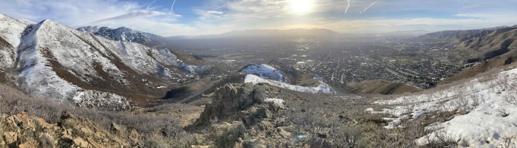
Located near the Natural History Museum of Utah, the Living Room Lookout Trail is a popular and rewarding hiking experience. This 2.3-mile trail, known for its accessibility and striking views, offers hikers a relatively short and simple, yet invigorating, journey to a unique destination.
The trailhead, easily accessible from the city, leads adventurers through the scenic foothills of the Wasatch Range. What makes this trail truly special is the “Living Room” of its namesake – a collection of large, flat sandstone slabs, positioned carefully, that resemble modernist living room furniture that are great for a quick snack.
Hikers are also rewarded with panoramic vistas of Salt Lake City and the surrounding valley, making it an ideal spot for both sunrise and sunset excursions. The relatively moderate difficulty of this trail makes it an attractive option for hikers of various skill levels, offering a memorable outdoor adventure that’s only a few minutes away from the urban city center.
- Difficulty: Intermediate
- Distance: 2.46 miles round trip (3.96 km)
- Height: 6,027 feet (1837.03 m)
- Elevation gain: 1,030 feet (313.94 meters)
- Duration: 2 hours
- Dogs: Allowed
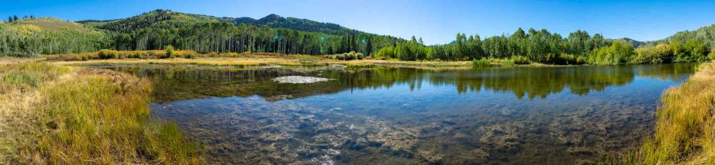
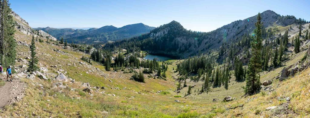
Lakes Catherine, Mary, and Martha
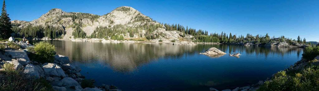
Views of Lake Mary
This lovely hike in Big Cottonwood Canyon takes you past three lakes. The trail starts by taking you up a ski run, but none of the sections are too steep for even little legs. The first mile to Lake Mary features stunning views, which continue along the next mile to Lake Martha. Lake Catherine has a trail going all the way around it, too. There are several side spurs that take you to the shoreline of Lake Martha, and fishing is allowed with a valid license. This trail is easily accessed and there is ample free parking at the Brighton resort.
- Difficulty: Easy
- Distance: 4.1 miles round trip (6.60 km) (shorter if only visiting Lake Catherine)
- Height: 9,946 feet (3031.54 m)
- Elevation gain: 1,230 feet (374.9 m)
- Duration: 4.5-6 hours
- Dogs: Not allowed
City Creek Canyon
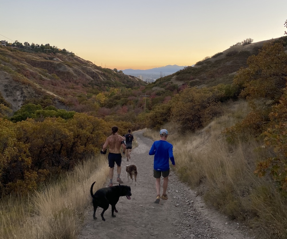
City Creek Canyon is a fantastic option as an easy hike location for a few reasons. It offers a paved hiking route up the canyon for easy walking, stroller pushing, biking, or handicap accessibility. Because this is a simple out and back along the road, visitors can choose to go however long they want. In addition to the paved path, there is a trail that parallels the road and hikers / runners can take various spinoff trails all around city creek canyon.
This is a trail we use all the time on the hot days in the summer as the canyon stays a lot cooler than many other areas.
Visitors can choose to start at the trailhead, or hike from the capitol building or even downtown.
- Difficulty: Easy
- Distance: Up to you!
- Elevation gain: Up to you!
- Duration: Up to you!
- Dogs: Allowed
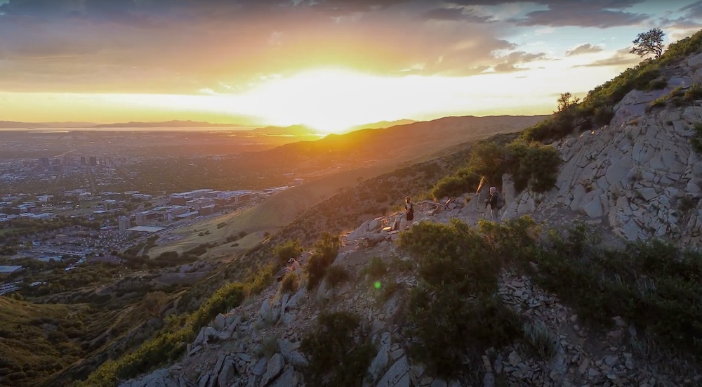
Ensign Peak
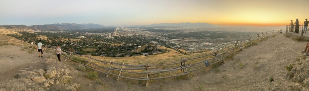
Ensign Peak is the fantastic overlook of Salt Lake City. The trail is easily to get to, features just a bit of elevation gain that makes it just a bit challenging for some families, but has great views as a reward. This is a very common destination for around sunset time.
This hike also has some unique and interesting history around the planning of Salt Lake City by from Brigham Young and other pioneers. This history is also explained on various educational signs near the trailhead, along the way, and at the summit.
- Difficulty: Easy
- Distance: 1 mile round trip
- Elevation gain: 600 feet
- Duration: 1 hour
- Dogs: Allowed
Jacks Mountain
Jacks Mountain is a great easy hike with stunning views. The parking lot is located in a neighborhood with stunning houses, and hikers can choose to hit a small summit about halfway up to shorten this hike and still get fantastic views. Located just off of Foothill drive, it is very convenient for anyone staying in east Salt Lake City.
- Distance – 2.4 miles round trip (3.9 km)
- Height – 6,455 feet (1967.5 m)
- Elevation gain – 1,400 feet (427 meters)
- Duration – 3.5 – 4 hours
- Difficulty – Easy to Intermediate
- Trailhead Locations – Jacks Mountain Trailhead
- Dogs: Allowed
Willow Lake
Willow Lake is less than 45 minutes away from downtown SLC and has incredible views of aspen groves, mountains, and the lake itself. Swimming and fishing aren’t allowed – the lake is too shallow to hold fish – but it’s a great view and a peaceful, easy trail. Moose sightings are frequent, so keep an eye out!
Whether you seek a quiet outdoor reprieve or the thrill of encountering local flora and fauna, Willow Lake promises a refreshing and picturesque respite near the center of Salt Lake City.
If you are looking for an easy, slightly lesser traveled fall foliage hike with lots of Aspens, this is a great option.
- Difficulty: Easy
- Distance: 2.31 miles round trip (3.72 km)
- Height: 8,508 feet (2593.24 m)
- Elevation Gain: 662 feet (201.78 m)
- Duration: 1.5-2+ hours
Best Salt Lake City Hikes for Intermediate Skill Levels
For outdoor adventurers in search of more challenging hikes, there are numerous options with varying terrain in a relatively close geographical locale.
Lake Blanche Trail
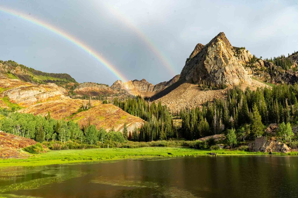
Lake Blanche with rainbows
Just a quick trip from the heart of SLC, Lake Blanche Trail, a captivating hiking experience, is renowned for its mesmerizing beauty and surrounding terrain. This 7-mile round-trip trail, located in Big Cottonwood Canyon, offers hikers a landscape with several defining characteristics – dense pine forests, rocky slopes, and picturesque alpine meadows.
The trail itself is straightforward and not technically challenging, it just has a significant amount of elevation gain, making it an intermediate to difficult hike.
The highlight of the trail, of course, is the lake itself; Lake Blanche is a pristine mountain lake surrounded by towering peaks (Mount Superior is located in the far back by the rainbow, and Sundial peak has cliffs that overlook the lake). Many choose to camp near the lake, and this area is frequented by moose as well. It is an incredible experience to see Moose near the lakes!
This is a very popular trail that gets busy during any weekend with decent weather. This is a long and tough hike for any beginner hikers.
- Difficulty: Intermediate-Hard
- Distance: 7 miles round trip
- Height: 8,920 feet (2718.82 m)
- Elevation gain: 2,787 feet (849.48 m)
- Duration: 5-6 hours (book time)
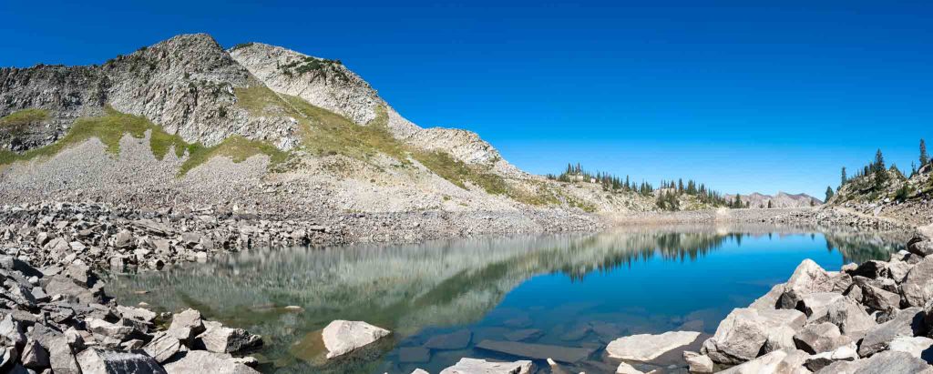
Red Pine Lake
Near the heart of the Wasatch Mountains, the Red Pine Lake Trail is a scenic, 6.9-mile round-trip hike that begins at the White Pine Trailhead in Little Cottonwood Canyon. This hike winds through the wilderness and nature enthusiasts can enjoy fragrant, pine forests and open meadows brimming with wildflowers and wildlife.
As the trail ascends, hikers will observe a dramatic shift in scenery, culminating in a stunning glacial cirque that cradles the pristine sub-alpine lake. Surrounded by jagged cliffs and treacherous, rocky ridges, the lake reflects the grandiosity of its surroundings, creating a captivating view for hikers.
The journey offers splendid panoramic views of the surrounding peaks, and for those that have already been here, an alternative to White Pine Lake (same trailhead, but diverges about 1 mile into hike) is a great option.
- Difficulty: Easy-Intermediate
- Distance: 6.96 miles round trip (11.20 km)
- Height: 9,600 feet (2926.08 m)
- Elevation gain: 2,220 feet (676.66 m)
- Duration: 5-6 hours
- Note: No dogs allowed on this trail
Mount Wire Trail
The Mount Wire Trail is yet another testament to local foothills having awesome hikes. Spanning approximately 4.8 miles, this trail ascends the iconic Mount Wire, giving hikers an enchanting mix of nature, historical intrigue, and breathtaking scenery.
The trailhead is easily accessible from the city and takes adventurers on an hours-long journey to the top. What sets Mount Wire apart is the tower, and ladder to the top of the tower at the summit. Hikers are able to climb a tower at the top for an incredible overlook of the city and mountain below.
The trail also offers excellent, sweeping panoramic views of Salt Lake City and the mountains, making this a favorite route for locals and visitors alike. The juxtaposition of natural beauty and old radio tower makes the Mount Wire Trail a distinctive and memorable hiking experience.
- Difficulty: Intermediate
- Distance: 4.8 miles round trip (7.72 km)
- Height: 7,110 feet (2167.13 m)
- Elevation gain: 2,100 feet (643 meters)
- Duration: 4-5 hours
Grandeur Peak
Grandeur Peak towers over the Salt Lake City area. It rises directly out of the valley on its West side, and features views of Salt Lake City, all the way to the salt lake, and even Utah lake far to the south.
On the backside, you can see the highest peaks in the Wasatch. With two common routes up this peak, this hike located just 15-20 minutes from downtown, is a common hike for locals and visitors combined.
The west face gets extremely hot during the say in the summer months, and is a very steep hike the entire way up. Starting within Millcreek canyon is a bit cooler in the summer months, and saves quite a bit of elevation gain.
- Difficulty: Intermediate
- Distance: 5.52 miles round trip (8.88 km)
- Height: 8,299 feet (2529.54 m)
- Elevation gain: 2,403 feet (732.43 m)
- Duration: 3-4 hours
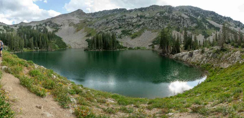
Sunset Peak
Sunset Peak and Lake Catherine from trail heading towards Catherine Pass
Sitting above Lake Catherine, Mary, and Martha. It features stunning views of the lakes below, but also 360 degree views of the surrounding peaks. Looking all the way over to Mount Timpanogos, across the canyons, and is relatively easy to access compared to other peaks at this elevation with these views.
This is a fantastic intermediate hike as the trail is quite straightforward, simple, and starts high enough to keep this peak in the intermediate category. We also love that hikers pass the lakes below, so this the first half of this hike is in the easy section of this article, and hikers can choose to continue on to this summit if they wish.
- Difficulty: Intermediate
- Distance: 5.62 miles round trip (9.04 km)
- Height: 10,648 feet (3245.51 m)
- Elevation gain: 1,936 feet (590.09 m)
- Duration: 4.5-6 hours
Best Salt Lake City Hikes for Experts
Seasoned hikers seeking a real challenge are practically spoiled for choice. Utah’s breathtaking vistas and otherworldly terrain offer some genuine once-in-a-lifetime experiences.
White Pine Lake Trail
Nestled in the picturesque Little Cottonwood Canyon only about a 40 minute drive from downtown Salt Lake City, the White Pine Lake Trail offers outdoor enthusiasts a captivating 10-mile round-trip journey through serene Utahn landscapes.
This moderately challenging trail begins with a gradual ascent through an old dirt and rocky road before revealing some exciting views of the rugged mountain terrain. What distinguishes White Pine Lake is its serene lake, cradled beneath the majestic surrounding peaks. The mirror-like surface of the water reflects the surrounding granite cliffs, creating a postcard-worthy scene that beckons hikers to linger and savor the tranquility.
Along the way, the trail meanders through wildflower-strewn meadows that add bright pops of color during the warmer months. As a less-frequented gem (once passing the first trail junction) among some of Salt Lake City’s best hiking trails, White Pine Lake offers a quieter, more contemplative outdoor escape for those in search of a deeper connection with the natural world. Here, hikers are treated to a sense of seclusion unlike any other hike on our list.
The trailhead parking does fill up fast due to it being a gorgeous area and starting point for a few different hikes. This is a long hike with a lot of elevation gain, but hikers hike all the way to the lake on an old dirt road, making it slightly easier than most other hiking trails of similar distance and elevation gain.
- Difficulty: Intermediate-Hard
- Distance: 10.1 miles round trip (16.25 km)
- Height: 9,945 feet (3031.24 m)
- Elevation gain: 2,995 feet (912.88 m)
- Duration: 6-7 hours
- Note: No dogs allowed on this trail
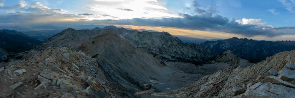
The Devils Castle
View this post on Instagram
The Devils Castle loop requires some class 4 or 5 scrambling, and is not a hike anyone with a fear of heights should tackle. It takes hikers along the ridge of Devils Castle with 3 spires of rock that appear to be impassable until you are actually on them. If you want the same views without the fear of heights, check out Sugarloaf Peak.
The views are absolutely incredible, but this route requires moves along rock that would result in serious injury or death with a mistake or slipping of rock.
If you like scrambling, big cliffs, and routes like this, it is one of our absolute favorite day trips in the canyon. An alternative wit hsimi
- Distance: 4.08 miles round trip (6.6 km)
- Height: 10,850 feet (3307.1 m)
- Elevation gain: 1,796 feet (547.4 meters)
- Duration: 3.5 – 4 hours
- Note: No dogs allowed on this trail
The Pfeifferhorn
Views from Pfeifferhorn Summit
This hike may just have some of the best views in all of the Wasatch Mountains. 360 degrees with incredible lakes down below, clear views of Lone Peak, the Salt Lake valley, and nearly the entire WURL route from one summit.
Hikers pass Red Pine lake on the way to this summit, making for some stellar views along the way, not just at the summit.
The last push to the summit requires some scrambling, and a steep and loose rock section to the summit.
If you are up for a solid day with about 4,000 feet of gain, this is also one of the “must do” hikes in the area.
- Distance: 9.9 miles round trip (15.9 km)
- Height: 11,362 feet (3463.1 m)
- Elevation gain: 3,933 feet (1198.8 meters)
- Duration: 6-8 hours
- Note: No dogs allowed on this trail
Mount Olympus
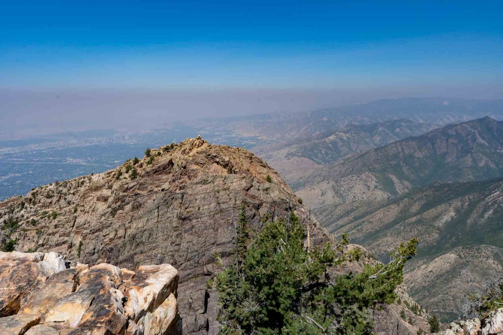
Views of Salt Lake City from the summit of Olympus on a smoky day
Mount Olympus is like the more difficult cousin of Grandeur Peak. It skyrockets up from the valley floor below, and is a huge mountain in terms of its base to summit height difference, even though the summit is at relatively low elevation compared to the biggest mountains in the Wasatch.
This hike kicks up in elevation quickly, and features absurdly gorgeous views of the valley below and the surrounding peaks. The last pitch to the summit is the most difficult section with some areas where you’ll want to use your hands, but overall, this is mainly a difficult hike simply due to the large amounts of elevation gain in a short period of time.
- Difficulty: Difficulty
- Distance: 6.6 miles round trip (10.62 km)
- Height: 9,026 feet (2751.13 m)
- Elevation gain: 4,190 feet (1277.11 m)
- Duration: 5-6 hours
General Tips for Hiking in and Around Salt Lake City
Before venturing into the Utahn wilderness and captivating hiking trails around Salt Lake City, a few essential tips can enhance your experience and ensure a safe, enjoyable excursion. Here are a handful of guidelines for beginners and practiced hikers alike:
Sun Protection
Given the region’s high elevation and abundant sunshine for much of the year, adequate sun protection is vital. Apply a broad-spectrum sunscreen with a high SPF rating to exposed skin, paying special attention to the face, neck, and ears. Reapply sunscreen throughout your hike, especially if sweating or near water. Wearing a wide-brimmed hat and sunglasses can provide an additional layer of defense against the intense ultraviolet rays of the mountain sun.
Hydration
Staying hydrated outdoors is paramount, especially in the arid mountain environs. Carry an ample supply of water, drink regularly, and be ready to turn back when you’ve drunk half of your water supply.
In the dry air, you may not feel as sweaty or notice how much your body is perspiring, but the body still loses water through respiration and bodily exertion. A reusable water bottle or hydration pack is essential for even short hikes.
Dog Rules
Utah has areas where dogs are not allowed. For example, any of the hikes in Big Cottonwood, or Little Cottonwood canyon. Wilderness areas also have regulations, and even where dogs are allowed, there are often rules around leash days and non leash days. Make sure you look for the rules for dogs in each of the areas before traveling.
Footwear and Clothing
Wear sturdy, comfortable hiking shoes that are suitable for varied terrain. Consider dressing in layers to accommodate temperature fluctuations as you hike and change elevation. Even on warmer days, mountain weather can change drastically, and a lightweight jacket or fleece can provide warmth and exposure protection at higher elevations or in the early hours of the evening.
Trail Etiquette
Respect trail etiquette to ensure a positive experience for you and your party and other hikers you may encounter. Yield to uphill hikers, stay on designated paths to protect vulnerable ecosystems, and be mindful of local wildlife. Leave no trace by packing out all waste, including food scraps, trash, and any other non-organic or organic materials.
Seasonal Considerations
As the seasons shift, so do trail conditions. In winter months, trails may be covered in snow or ice. Equip yourself with the appropriate gear, such as traction devices for your shoes and trekking poles for added stability. Check trail conditions regularly and weather forecasts before you head out.
Safety Preparedness
Inform someone about your hiking plans and expected return time. Carry a fully charged phone, but be aware that signal strength may be limited in remote areas, especially in valleys. Bring a basic first aid kit, a map or a GPS device, and brush up on your basic navigational skills.
By sticking to these guidelines, hikers can make the most of their outdoor adventures in Salt Lake City, ensuring a safe, enjoyable, and respectful experience amidst the many natural wonders of the region.
Hikes Within 2 Hours of Salt Lake City
We also left some of our favorite hikes near the Salt Lake City area out of this list either due to difficulty, or due to them being outside an hour drive from the downtown area. Here are some of our notable mentions:
Lone Peak – Lone Peak has an incredibly unique landscape with absolutely insane views. This hike features a very large 5,500 foot plus vertical gain on the shortest route, making it a very difficult day hike, but definitely doable for avid hikers.
Mount Timpanogos – Timp features one of the most gorgeous glacial cirques and incredible landscapes in all of Utah. It has a few route options to the top, and the summit features incredible cliff drops, views overlooking Utah Lake, and a large portion of the Wasatch. The contrast of this giant mountain that rises directly from the towns at the valley below is incredible.
The WURL – This is a mountaineering and ultra athlete route gaining in popularity due to extreme difficulty and danger. Finishing the WURL requires endurance, skills with mountaineering, and aligning weather conditions.
Fifth Water Hot Springs – A stunning hot spring located about an hour and 15 minutes south of Salt Lake City, this place features several hot spring pools, waterfalls, and is a must visit for anyone that loves hot springs. It does get quite busy.
Frary Peak, Antelope Island – Antelope Island is a different style as it is located a bit northwest of Salt Lake City. This is a large island rising out of the Great Salt Lake. The terrain is incredibly unique, and the island even features a herd of bison. There are many hikes on this island, Frary Peak is just the highest point.
Terrace Hills Trailhead – This trailhead has some great family friendly walking and biking trails located in the Avenues of Salt Lake City. In less than a quarter mile, hikers can be seeing stunning views of Salt Lake City. You can go for many miles on various trails back here with great views, or just do a quick 10 minute walk. This is a common local spot.
Something for Everyone
Salt Lake City’s surrounding landscapes host a wide range of remarkable recreational and hiking trails, each offering a healthy dose of Earth’s natural beauty and outdoor adventure.
As we’ve seen, these trails cater to a wide range of skill levels to ensure that everyone, from novice enthusiasts to hardened mountaineers, can find a path that suits their preferences. There’s no shame in starting with beginner trails – every step of the way is a victory.
Beyond the physical benefits of hiking, these trails also provide a much-needed escape from the rigamarole and bustle of daily life, offering moments of tranquility that foster a deeper connection to nature.
So lace up those hiking boots, fill your water bottle, and get ready to embark on your next outdoor adventure. Whether it’s the thrill of completing a challenging trail or the simple joy of immersing oneself in nature’s wonders, the trails in and around Salt Lake City beckon explorers of all types.
Max DesMarais is the founder of hikingandfishing.com. He has a passion for the outdoors and making outdoor education and adventure more accessible. Max is a published author for various outdoor adventure, travel, and marketing websites. He is an experienced hiker, backpacker, fly fisherman, backcountry skier, trail runner, and spends his free time in the outdoors. These adventures allow him to test gear, learn new skills, and experience new places so that he can educate others. Max grew up hiking all around New Hampshire and New England. He became obsessed with the New Hampshire mountains, and the NH 48, where he guided hikes and trail runs in the White Mountains. Since moving out west, Max has continued climbed all of the Colorado 14ers, is always testing gear, learning skills, gaining experience, and building his endurance for outdoor sports. You can read more about his experience here: hikingandfishing/about